|

|
[[en]]OVERVIEW[[hi]]अवलोकन
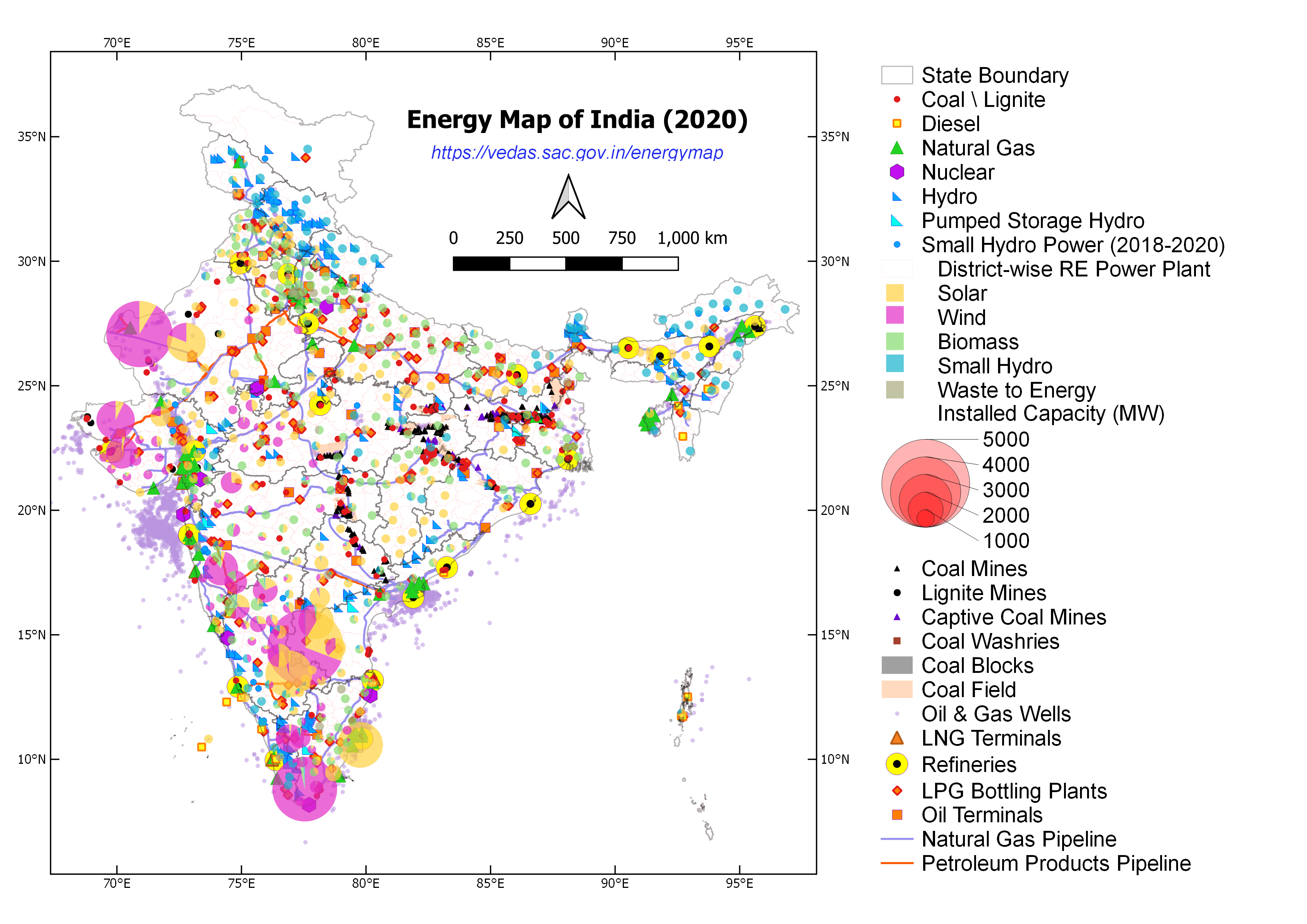
[[en]]The energy data in India is fragmented and scattered across multiple departments/ministries. The energy ministries have developed maps about the sectors that they are engaged in for their own consumption such as the National Power Portal (CEA), Online Coal Block Information System (CMPDIL), India Online Exploration Database (DGH), etc. These maps are extensive in the area they cover but they are unable to provide a holistic picture of the entire energy sector. Mostly, the available maps are static (i.e. in PDF or JPG formats) as a result of which they are unable to show the associated features of the topography where critical energy attributes may be located.[[hi]]भारत में ऊर्जा डेटा कई विभागों / मंत्रालयों में खंडित और बिखरा हुआ है। ऊर्जा मंत्रालयों ने अपने स्वयं के उपयोग के लिए उन क्षेत्रों के नक्शे विकसित किए हैं जिसमें वे लगे हुए हैं जैसे कि राष्ट्रीय ऊर्जा पोर्टल (सीईए), ऑनलाइन कोयला ब्लॉक सूचना प्रणाली (सीएमपीडीआईएल), भारत ऑनलाइन अन्वेषण डेटाबेस (डीजीएच), इत्यादि। ये मानचित्र जिस क्षेत्र के अंतर्गत आते हैं, उसमें विस्तृत हैं, लेकिन पूरे ऊर्जा क्षेत्र की समग्र तस्वीर प्रदान करने में असमर्थ हैं। अधिकाशतः, उपलब्ध नक्शे स्थिर हैं (यानी पीडीएफ या जेपीजी प्रारूपों में) जिसके परिणामस्वरूप वे स्थलाकृति की संबंधित विशेषताओं को दिखाने में असमर्थ हैं जहां महत्वपूर्ण ऊर्जा विशेषताएँ पाई जा सकती हैं।
[[en]]Keeping the above perspective in mind, the NITI Aayog collaborated with Indian Space Research Organisation (ISRO) and signed a Memorandum of Understanding (MoU) on June 07, 2017 to develop a comprehensive GIS-based Energy Map of India. The process of developing GIS maps started with a meeting with Ministry of Coal, Ministry of Power, Ministry of New and Renewable Energy, Ministry of Petroleum and Natural Gas, and Department of Atomic Energy. During the discussions, these ministries were requested to appoint nodal officers to provide relevant information and data coordinates. The GIS map in current form represents a holistic picture of all energy resources. The web-based geospatial energy map of India includes visualisation of spatial and non-spatial data on renewable and non-renewable power plants, oil and gas downstream sector, renewable energy potential, fossil fuel resources, and other energy assets in India.[[hi]]उपर्युक्त परिप्रेक्ष्य को ध्यान में रखते हुए, नीति आयोग ने भारतीय अंतरिक्ष अनुसंधान संगठन (ISRO) के साथ सहभागिता की और भारत का व्यापक जीआईएस-आधारित ऊर्जा मानचित्र विकसित करने के लिए 07 जून, 2017 को एक समझौता ज्ञापन (MoU) पर हस्ताक्षर किए। जीआईएस मानचित्रों को विकसित करने की प्रक्रिया कोयला मंत्रालय, विद्युत मंत्रालय, नवीन और नवीकरणीय ऊर्जा मंत्रालय, पेट्रोलियम और प्राकृतिक गैस मंत्रालय तथा परमाणु ऊर्जा विभाग के साथ बैठक के साथ शुरू हुई। चर्चा के दौरान, इन मंत्रालयों को प्रासंगिक जानकारी और डेटा निर्देशांक प्रदान करने के लिए नोडल अधिकारी नियुक्त करने का अनुरोध किया गया। वर्तमान स्वरूप में जीआईएस नक्शा सभी ऊर्जा संसाधनों की समग्र तस्वीर का प्रतिनिधित्व करता है। भारत के वेब-आधारित भू-स्थानिक ऊर्जा मानचित्र में भारत में नवीकरणीय और गैर-नवीकरणीय ऊर्जा संयंत्रों, तेल और गैस के अनुप्रवाह क्षेत्र, नवीकरणीय ऊर्जा क्षमता, जीवाश्म ईंधन संसाधन और अन्य ऊर्जा परिसंपत्तियों के स्थानिक और गैर-स्थानिक डेटा का दृश्यीकरण शामिल है।
[[en]]The GIS-based energy map of India may be useful for geospatial planning of resource. The planning may include infrastructure planning for upcoming solar parks, coal blocks, crude oil and natural gas pipelines, investment guidance for financial institutions, disaster management of possible energy disruption and emergency response, safety of energy assets due to harsh climatic conditions. This may also help in resource and environmental conservation measures, inter-state coordination on infrastructure planning including different corridors of energy and road transport highway.[[hi]]भारत का जीआईएस-आधारित ऊर्जा मानचित्र संसाधन की भू-स्थानिक योजना के लिए उपयोगी हो सकता है। योजना में आगामी सौर पार्कों, कोयला ब्लॉकों, कच्चे तेल और प्राकृतिक गैस पाइपलाइनों के लिए बुनियादी ढांचा योजना, वित्तीय संस्थानों के लिए निवेश मार्गदर्शन, संभावित ऊर्जा व्यवधानों का आपदा प्रबंधन और आपातकालीन प्रतिक्रिया, कठिन जलवायु परिस्थितियों के मध्य ऊर्जा परिसंपत्तियों की सुरक्षा शामिल हो सकती है। यह संसाधन और पर्यावरण संरक्षण के उपायों, ऊर्जा और सड़क परिवहन राजमार्ग के विभिन्न गलियारों सहित बुनियादी ढांचे की योजना पर अंतर-राज्य समन्वय में भी मदद कर सकता है।
[[en]]India has opened up various aspects of energy exploitation (generation/ conversion/ transmission/ consumption) to private sector. Energy markets have immense potential to bring in efficiency gains. Therefore, GIS-based mapping of energy assets will be advantageous to all concerned stakeholders and will help in accelerating the policy-making process.[[hi]]भारत ने ऊर्जा दोहन (उत्पादन / रूपांतरण / पारेषण / खपत) के विभिन्न पहलुओं को निजी क्षेत्र के लिए खोल दिया है। ऊर्जा बाजारों में दक्षता हासिल करने की अपार संभावनाएं हैं। इसलिए, ऊर्जा परिसंपत्तियों का जीआईएस आधारित मानचित्रण सभी संबंधित हितधारकों के लिए फायदेमंद होगा और नीति बनाने की प्रक्रिया को तेज करने में मदद करेगा।
